

In 1980, the Moll de la Fusta area was a huge expanse of asphalt with seven lanes of traffic in either direction, separated from the port area by a fence and the port rail lines. Between 1981 and 1987, when Moll de Bosch i Alsina was opened to the public, the area was remodelled in several phases, re-distributing traffic, creating recreational areas, resolving various urban needs and re-zoning the space as a monumental area, the image of Barcelona’s return to its Port. The wall enclosing the ring road consolidated the historical duality of the space, city and port, and helped clarify management under the framework of a united urban vision.
The intense use of spaces in the old port, increased demand for longitudinal traffic (cars, cycles, tourists), the disappearance of the beach bars, which brought life to the area, and the unfortunate renovation of the port esplanade and elevated balcony 15 years ago have eroded the quality of the space and made it much less comfortable and accessible. Additionally, there is a growing divide between the criteria of the Autonomous Port, which has authority over the port area, and the City, which is responsible for the urban strategy for all of Moll de la Fusta
Neighbourhoodification of Moll de la Fusta
The Neighbourhood Plan for the Southern Raval and Southern Gothic Quarter, which aims to neighbourhoodify public spaces, has established there is a need to forge strong, clear ties between the compact network of the southern Gothic Quarter and the open spaces of Moll de la Fusta to reinforce its feeling of proximity. These spaces today are not very welcoming for temporary or permanent recreational and leisure activities, which contribute to the wellbeing of residents in the southern Gothic Quarter. It is necessary, thus, to make compatible the updated values of the city scale, which are formal and functional, with a more local vision to consolidate Moll de la Fusta as the great open space of Ciutat Vella.
Neighbourhoodification to re-appropriate Moll de la Fusta as a social centre for the neighbourhood, this is the goal. In Ciutat Vella, it is difficult to enjoy daily life in the streets and squares, mainly because the neighbourhood is saturated and the small public spaces are highly sought after for outdoor seating, non-local consumers, service activities and private transport vehicles. The Moll de la Fusta space is just opposite the neighbourhood but residents don’t use it because it is hard to get to and there is too much traffic, noise, sun, tourists and tourist-based services. We must, therefore:
1. Improve accessibility from the neighbourhood to the various parts of Moll de la Fusta. The puzzle of transversal neighbourhood mobility must be solved with clear, easy routes, as compared to the longitudinal vehicle mobility (cars, buses, cycles, tourists) and associated services (loading/unloading, stops, etc.).
2. Getting back a quality, comfortable environment in each of the areas. People should be able to enjoy each place, spend time without any other pretensions, simply because they are open spaces, with less pressure, without sharp borders, with soil, trees, shade, views, breezes, etc., so different from the compact Ciutat Vella neighbourhood.
3. Identify each space’s potential for use by residents based on is physical qualities, materials, pace and size, and its position within the whole area. From Ample, through the Mercè neighbourhood, a green Hall for local activities, a Balcony for lounging, sun and shade and views, and an Esplanade as multi-purpose space, without a defined use
These prospective elements to be studied must be presented to neighbours, and others involved in managing and using Moll de la Fusta, to decide on the short-, middle- and long-term actions and define the regeneration strategy collectively.
Accessibility and comfort
Public action to facilitate active use of the Moll de la Fusta spaces by Ciutat Vella residents, in the short and middle term, must focus on the Hall and the Balcony, both under municipal management and, therefore, places that allow for direct action. The goal in the first stage is to make these two spaces accessible and comfortable, ensuring residents can reach them and enjoy them. We must, then, lay out actions involving the Hall and the Balcony, as well as the intermediate road space, to establish conditions for daily use by residents of nearby areas, clarifying the limits, gaining space for lounging, facilitating access and improving the environment and comfort.
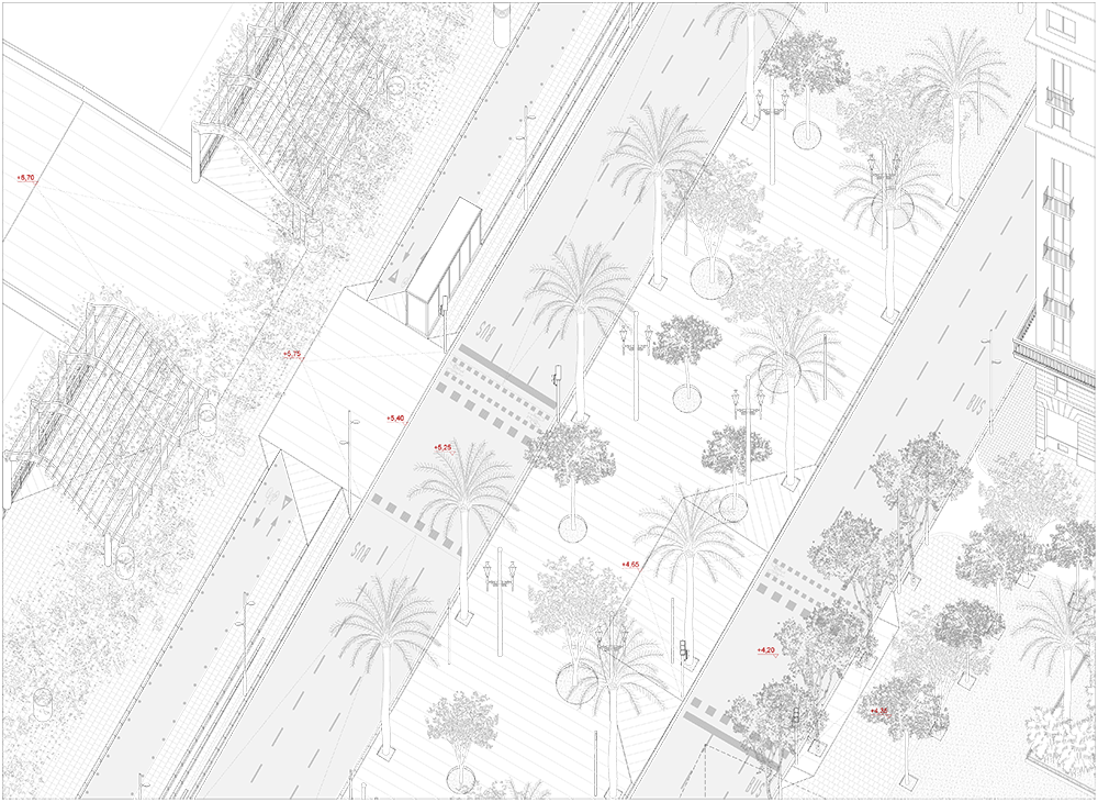
The Hall
An 18-metre strip where trees and bushes could be planted in soft ground, moving the bus to the side lanes to reinforce the Ciutadella–Montjuïc corridor and house a series of spaces for neighbourhood activities run by local facilities or bodies.
The Balcony
A static space 15 metres wide. With plant pergolas and kiosks, it could be a shady spot to look out over the port and Passeig de Colom. There is space for soft modes of transport along its length, pedestrians and cyclists.
The roads
The lanes on Passeig de Colom, which can be widened to 9 metres, should have a separate bus lane; the cycle path on the Balcony, properly marked and newly paved, should allow for cyclists to continue their path towards Ciutat Vella and have pedestrian crossings; the car park should only have traffic flowing in one direction.
At the same time as the short- and middle-term actions, we must work on recognising the physical, economic and social conditions in the Mercè-Ample area and come up with a clear, united urban vision with the port based on a complex, dynamic of study, prospective diagnosis and negotiation.
This study, drafted from the summary of generic municipal maps and some field work, establishes actions, intentions and arguments for how to handle and change the space between the urban façade of Passeig de Colom and the railing of the Balcony over the ring road. Based on preliminary studies submitted, it will be necessary to create a more precise topographic map of the area to precisely establish the actions and move forward with projects. Particular attention must be paid to the elevation profiles in the proposed transversal pathways.
Transversality is the key to tackling the regeneration of these spaces, ensuring accessibility and resolving the continuity issues of all routes. It is essential that this transversality is supported not only through traffic-light management and regulation, but that it is also materialised in topographic changes to the ground slopes and proper ground-cover materials to promote continuity.
To ensure this transversality, one of the main instruments used is superimposition. We must move past the idea of a single level road and pavement throughout and introduce a new scale of longitudinal alteration marked by the superimposed plane extending Plaça Medinaceli and small junctures at each of the crossings in front of the streets. This way, the longitudinal profile regains a feeling of unity and highlights that it is a unique space between monuments.
Adding green spaces, trees and climbing plants is another great resource in the project to regenerate Moll de la Fusta. It must improve the quality and comfort of the space, adding shade and colour, making the passing seasons visible. Deciduous trees and green pergolas accentuate the look of the whole area and reinforce the differences. The vegetation helps create pleasant leisure spaces that are seen as calming. The continuity of the green axis between Ciutadella and Montjuïc creates an ecological corridor belonging to Barcelona’s system of biodiversity spaces.
Actions for the short and middle term on Passeig de Colom.
The Hall
In the Hall, without buses, deciduous trees should be planted not in straight lines following the palm trees and monumental street lights but scattered around naturally. This plantation, which radically changes the character and use of the space, creates three spaces with blurred borders for neighbourhood activities led by facilities nearby, framed by the “squares” Medinaceli, Capitanía, Colom and Correos. The new ground cover, soft and permeable, accentuates this rosary of neighbourhood areas, adapting to the transversal slopes, different at each crossing, and the topographic undulations that ensure urban unity with the transversal sequence of Passeig de Colom, between the façade and the railing of the Balcony. Changing the width of the roads on either side of the Hall doesn’t alter its basic width, delimited by the two lines of palm trees.
The Balcony
On the Balcony, create plant shade, large pergolas/parasols, mesh of metal bars for climbing plants in planters on the ground to stabilise them. The exuberance and variety of the plants, species, colours and smells brings quality to the space, reinforcing its scale and the third dimension, creating the shade and fresh air one would find in a contemplative spot. They should be put on top of the structural pillars of the car park, in irregular groups to create their own rhythm, compatible with foot traffic. The double roofs of the old beach bars, part of this linear system, signal the arrival of the two future crossings over the ring road. Mariscal’s shrimp is kept as a piece of public art and a gateway to the Balcony. To improve the acoustic protection from traffic noise on the ring road, the railing is modified to incorporate a screen and planter, valorising the ceramic balustrade.
The roads
Passeig de Colom gets a bus lane in both directions from one end to the other. To do so, it must be freed of uses associated with tourists that limit its capacity and stops must be identified. The lane on the port side, running towards Correos, is raised to the level of the first step (+17 cm) along the length to facilitate adapting the slopes to the transversal crossings. This can take advantage of repositioning the kerbs to widen it 0.6 metres and gain the space needed for a segregated bus lane. This means replacing the 21 existing palm trees between the steps on the Balcony with bushes or climbing plants that can take advantage of the smaller tree well resulting from this change. The lane on the city side is widened 0.6 metres, maintaining the current gradient, without having to change the location of the pavement on city side of the avenue. The transversal crossings proposed are compatible with both the current width of the roads and the 0.6 wider version.
The longitudinal cycle lane stays where it is, on top of the slab of the car park, delimited by the kerb that separates it from the Balcony and the stairs up from the road level, acting as a waiting area with access to the car park and adapted ramps for the transversal routes. The cycle path should be paved with asphalt to set it apart as a traffic route. The crossings with the transversal routes must be resolved with priority, topography and materials, in favour of pedestrians to prevent uncontrolled speed and allow cyclists to turn up into the city. On either end, the cycle path must narrow, compatible with pedestrian access from Correos and Colom, next to the car park ramps to hook up properly with the city’s cycle path network.
Gateways
Plaça Medinaceli is one of the “gateways” from the neighbourhood to the port area. On Passeig de Colom, the whole width of the square, a great sloping plane (3%) will run from the pavement level to the highest point of the Balcony at the old beach bars, culminating with a new crossing over the ring road with direct access to the esplanade of Moll de Bosch i Alsina. This plane distorts the longitudinal profiles, which must adapt to it, and is a topographical alteration that makes this point of the avenue unique. Pedestrian routes from Carrer del Regomir cross directly towards the Hall and turn off to get to the Hall, which is the highest at this point. This alteration is complementary, softening the hard linear nature of the avenue.